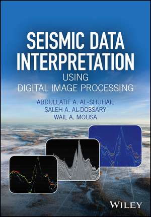
Seismic Data Interpretation using Digital Image Processing
Autor Abdullatif A. Al-Shuhailen Limba Engleză Hardback – 25 aug 2017
Destinată studenților de la masterat și doctorat, dar și cercetătorilor din ingineria electrică și geofizică, această lucrare publicată de John Wiley & Sons, Inc. reprezintă un punct de legătură esențial între procesarea modernă de imagine și interpretarea seismică. Considerăm că valoarea principală a volumului constă în modul în care transpune conceptele teoretice de semnal și imagine în instrumente practice pentru explorarea geologică. Descoperim aici o structură riguroasă, unde fiecare algoritm este validat prin exemple de date sintetice și studii de caz reale, oferind o perspectivă tehnică necesară pentru dezvoltarea de noi soluții software și hardware. Merită menționat că volumul pune un accent deosebit pe accesibilitate, explicând tehnicile de interpretare din punctul de vedere al unui specialist în procesarea semnalelor digitale. Această abordare este complementară unor titluri precum Numerical Methods of Exploration Seismology de Gary F. Margrave, care se concentrează pe aspectele computaționale și numerice. Totuși, lucrarea de față se diferențiază printr-o orientare mult mai aplicată spre procesarea de imagine, oferind cititorului algoritmi MATLAB gata de execuție, o facilitate pe care o regăsim și în Processing of Seismic Reflection Data Using MATLAB de Wail A. Mousa. În contextul operei autorului Wail A. Mousa, acest titlu extinde temele abordate în Advanced Digital Signal Processing of Seismic Data, trecând de la procesarea semnalului 1D la complexitatea structurilor 2D și 3D specifice imaginilor seismice. Este o resursă academică ce elimină barierele dintre discipline, fiind relevantă atât pentru mediul universitar, cât și pentru specialiștii care doresc să implementeze tehnici avansate de vizualizare a rezervoarelor de hidrocarburi.
Preț: 609.55 lei
Preț vechi: 791.62 lei
-23%
Carte disponibilă
Livrare economică 24 octombrie-07 noiembrie
Livrare express 13-17 octombrie pentru 36.55 lei
Specificații
ISBN-10: 1118881788
Pagini: 242
Dimensiuni: 170 x 244 x 14 mm
Greutate: 0.59 kg
Editura: Wiley
Locul publicării:Chichester, United Kingdom
V-ar putea interesa
-
 -12%Preț: 377.59 lei427.68 lei
 -
 Digital Signal ProcessingEmmanuel Ifeachor-20%Preț: 572.74 lei715.93 lei
 -
 -40%Preț: 608.24 lei1015.17 lei
 -
 -24%Preț: 143.13 lei189.40 lei
 -
 Theoretical and Computational SeismologyJeroen Tromp-14%Preț: 555.67 lei646.12 lei
 -
 Remote Sensing and Image InterpretationThomas Lillesand-18%Preț: 1345.99 lei1641.45 lei
 -
 Computation, Optimization, and Machine Learning in SeismologySubhashis Mallick-20%Preț: 791.40 lei989.24 lei
 -
 The Image Processing HandbookJohn C. Russ-20%Preț: 755.93 lei944.91 lei
 -
 Digital Image Processing, Global EditionRafael Gonzalez-11%Preț: 654.09 lei734.93 lei
 -
 The Art and Science of Seismic InterpretationChristopher L. Liner-15%Preț: 448.12 lei527.19 lei
 -
 Fundamentals of Music ProcessingMeinard Müller-20%Preț: 379.20 lei474.00 lei
 -
 Oil and Gas Reservoir Prospecting and ExplorationVladimir L. Trofimov-24%Preț: 785.34 lei1033.34 lei
 -
 Digital Image ProcessingWilhelm Burger-20%Preț: 687.98 lei859.97 lei
 -
 Image Analysis in Earth SciencesRenée Heilbronner-18%Preț: 979.24 lei1194.19 lei
 -
 -20%Preț: 613.19 lei766.48 lei
 -
 Advance Concepts of Image Processing and Pattern RecognitionNarendra Kumar-20%Preț: 1071.56 lei1339.45 lei
 -
 Advancing Subsurface Imaging, Energy Transition and Digital InnovationNumair Ahmed Siddiqui-18%Preț: 1402.19 lei1709.99 lei
 -
 -15%Preț: 693.71 lei816.13 lei
Public țintă
TIER 2Primary: Senior undergraduates and graduate students in electrical engineering; graduate students in earth sciences.
Secondary: Image processing researchers wanting to gain an understanding in exploration seismology; seismic data interpreters wanting to learn more advanced techniques used from digital image processing.
De ce să citești această carte
Această carte este indispensabilă pentru cei care vor să aplice procesarea de imagine în geofizică. Dincolo de teorie, câștigați acces la algoritmi MATLAB funcționali, ceea ce scurtează considerabil drumul de la concept la implementare. Este recomandarea noastră pentru masteranzii în inginerie care doresc să se specializeze în interpretarea seismică sau pentru programatorii care dezvoltă software de explorare, oferind rigoarea tehnică necesară într-un format practic.
Despre autor
Abdullatif A. Al-Shuhail, Saleh A. Al-Dossary și Wail A. Mousa sunt experți recunoscuți în intersecția dintre geofizică și procesarea semnalelor. Wail A. Mousa are o contribuție academică semnificativă, publicând anterior lucrări de referință despre utilizarea mediului MATLAB în seismologie și procesarea avansată a semnalelor. Expertiza lor colectivă combină cercetarea academică de înalt nivel cu aplicațiile industriale, oferind o perspectivă autoritară asupra modului în care tehnologia digitală transformă interpretarea datelor geologice în industria extractivă.
Descriere scurtă
Notă biografică
Cuprins
Preface xv
1 Introduction 1
1.1 Image Processing of Exploration Seismic Data 1
1.2 Exploration Seismic Data: From Acquisition to Interpretation 1
1.2.1 Seismic Data Acquisition 2
1.2.2 Seismic Data Processing 2
1.2.3 Seismic Data Interpretation 2
1.3 The Seismic Convolution Model 3
1.4 Summary 6
2 Seismic Data Interpretation 7
2.1 Introduction 7
2.2 Structural Features 11
2.2.1 Faults 11
2.2.2 Folds 18
2.2.3 Diapirs 21
2.3 Stratigraphic Features 22
2.3.1 Channels 24
2.3.2 Reefs 26
2.3.3 Truncation 27
2.4 Seismic Interpretation Tools 27
2.4.1 Seismic Sequence Stratigraphy 29
2.4.2 Seismic Facies Analysis 33
2.4.3 Direct Hydrocarbon Indicators 35
2.4.4 Tying Seismic and Well Data 35
2.4.5 Seismic Modeling 35
2.4.6 Time-to-Depth Conversion 41
2.4.7 Seismic Attributes 44
2.5 Pitfalls in Seismic Interpretation 44
2.6 Summary 48
2.7 Problems and Computer Assignments 49
3 Seismic Image Enhancement in the Spatial Domain 59
3.1 Introduction 59
3.1.1 The Mean (Running-Average) Filter 60
3.2 The Median Filter 63
3.3 The Edge-Preserving Smoothing Algorithm 66
3.3.1 Two-Dimensional Structure-Preserving Smoothing 67
3.4 Wavelet-Based Smoothing 70
3.4.1 Method 70
3.4.2 Sharpening Filter 71
3.5 Summary 72
3.6 Problems and Computer Assignments 73
4 Seismic Image Enhancement in the Spectral Domain 77
4.1 Introduction 77
4.2 The Fourier Transform 77
4.3 Filtering in the Spectral Domain 80
4.4 Spectral Attributes 83
4.5 Summary 85
4.6 Problems and Computer Assignments 85
5 Seismic Attributes 87
5.1 Introduction 87
5.2 Detection of Interesting Regions from Time or Depth Three-Dimensional Slices using Seismic Attributes 87
5.3 Two-Dimensional Numerical Gradient Edge-Detector Operators 89
5.4 Application to Real Seismic Data 91
5.5 Two-Dimensional Second-Order Derivative Operator 96
5.5.1 The Coherence Attribute 96
5.5.2 The Dip Attribute 100
5.6 The Curvature Attribute 101
5.7 Curvature of the Surface 103
5.7.1 Curve, Velocity, and Curvature 103
5.7.2 Surface, Tangent Plane, and Norm 104
5.8 Shape Operator, Normal Curvature, and Principal Curvature 105
5.8.1 Normal Curvature 105
5.8.2 Shape Operator 105
5.8.3 The Principal Curvatures 106
5.8.4 Calculation of the Principal Curvatures 106
5.8.5 Summary of Calculation of Principal Curvature for a Surface 107
5.9 The Randomness Attribute 108
5.10 Technique for Two-Dimensional Images 109
5.10.1 Problem Statement and Preliminaries 109
5.10.2 Review of Fast Noise Variance Estimation Algorithm 110
5.10.3 Design Mask by Constrained Optimization 111
5.11 The Spectral Decomposition Attribute 113
5.12 Summary 115
5.13 Problems and Computer Assignments 116
6 Color Display of Seismic Images 123
6.1 Introduction 123
6.2 Color Models and Useful Color Bars 124
6.2.1 The RGB Model 125
6.2.2 The CMY Model 125
6.2.3 The HSI Model 126
6.2.4 Useful Color Bars 127
6.3 Overlay and Mixed Displays of Seismic Attribute Images 127
6.4 Summary 130
6.5 Problems and Computer Assignments 130
7 Seismic Image Segmentation 133
7.1 Introduction 133
7.2 Basic Seismic Image Segmentation 134
7.3 Advanced Seismic Image Segmentation 136
7.3.1 Color-Based Segmentation 136
7.3.1.1 The Imposed Constraints for the POCS Color Segmentation Method 137
7.3.2 Graph-Based Segmentation 139
7.4 Automatic Fault Extraction 140
7.5 Summary 143
Glossary 145
References 151
Index 157