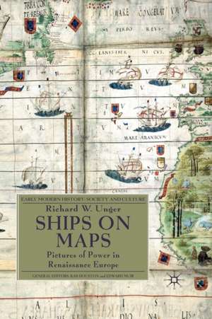
Ships on Maps: Pictures of Power in Renaissance Europe: Early Modern History: Society and Culture
Autor Richard W. Ungeren Limba Engleză Paperback – 4 aug 2010
Din seria Early Modern History: Society and Culture
- 15%
 Preț: 619.61 lei
 - 15%
 Preț: 612.49 lei
 - 16%
 Preț: 318.18 lei
 -
 Preț: 402.61 lei
 - 18%
 Preț: 897.88 lei
 - 8%
 Preț: 579.90 lei
 - 15%
 Preț: 605.75 lei
 -
 Preț: 368.01 lei
 -
 Preț: 366.84 lei
 - 15%
 Preț: 664.06 lei
 - 15%
 Preț: 608.87 lei
 - 18%
 Preț: 1069.45 lei
 -
 Preț: 366.60 lei
 - 15%
 Preț: 607.08 lei
 - 18%
 Preț: 692.28 lei
 - 15%
 Preț: 557.76 lei
 - 15%
 Preț: 620.68 lei
 - 15%
 Preț: 611.83 lei
 -

-

Preț: 614.41 lei
Preț vechi: 722.83 lei
-15%
Puncte Express: 922
Carte tipărită la comandă
Livrare economică 31 august-14 septembrie
Livrare prin curier în România Termenul estimat este afișat lângă disponibilitate.
Transport gratuit pentru acest produs Plată online sau ramburs, în funcție de opțiunile comenzii.
Retur gratuit în 14 zile Comandă securizată și suport în română.
Specificații
ISBN-13: 9781349312078
ISBN-10: 134931207X
Pagini: 233
Ilustrații: XXIII, 233 p. 52 illus., 8 illus. in color.
Dimensiuni: 155 x 235 x 14 mm
Greutate: 0.38 kg
Ediția:1st ed. 2010
Editura: Palgrave Macmillan UK
Colecția Palgrave Macmillan
Seria Early Modern History: Society and Culture
Locul publicării:London, United Kingdom
V-ar putea interesa
-
 Vanished KingdomsNorman Davies-18%Preț: 113.38 lei137.63 lei
 -
 Eminent ElizabethansPiers BrendonPreț: 173.83 lei
 -
 Film, Memory and the Legacy of the Spanish Civil WarMercedes Maroto CaminoPreț: 392.04 lei
 -
 Surviving Hitler's WarHester VaizeyPreț: 419.42 lei
 -
 Russian and Soviet Diplomacy, 1900-39Alastair Kocho-Williams-15%Preț: 693.55 lei815.94 lei
 -
 WallensteinGeoff Mortimer-18%Preț: 768.05 lei936.65 lei
 -
 Serbia and the Serbs in World War TwoSabrina P. RametPreț: 394.16 lei
 -
 Joseph GoebbelsToby ThackerPreț: 432.91 lei
 -
 After the Dresden BombingAnne Fuchs-15%Preț: 704.10 lei828.35 lei
 -
 The Victims Return: Survivors of the Gulag After StalinStephen F. Cohen-18%Preț: 140.85 lei171.43 lei
 -
 Introducing the Freud WarsStephen WilsonPreț: 56.59 lei
 -
 -34%Preț: 761.75 lei1149.57 lei
 -
 Albert KesselringPier Paolo Battistelli-32%Preț: 76.52 lei113.10 lei
Cuprins
List of illustrations Preface Acknowledgements Abbreviations Glossary of Shipbuilding Terms Introduction Maps and Mapping Making Maps without Ships, with Ships Mapping before the Renaissance Portolans and the Late Medieval Transition The Classical Revival, Printing and Maps New Routes and Portuguese Map Makers Iberian Influence in Southern Europe Northern Europe and Southern Practices Ships, Geography, and Humanism Epilogue Bibliography Notes Index
Notă biografică
RICHARD W. UNGER trained as an economic historian and has published widely on ships and shipping before 1800, brewing from the Middle Ages to the twentieth century and on energy use and its impact in pre-modern Europe. He has taught history at the University of British Columbia for more than four decades.