Worcestershire 1610 - 1836 - Fold Up Map that features a collection of Four Historic Maps, John Speed's County Map 1610, Johan Blaeu's County Map of 1648, Thomas Moules County Map of 1836 and Cole and Roper's Plan of the City of Worcester 1805. The map's also features early Victorian views from around Worcestershire.
20 dec 2018
Paperback
Preț: 143.23 lei
3-5 săpt. | 6-12 zile
A Lancashire 1611 - 1836 - Fold Up Map that features a collection of Four Historic Maps, John Speed's County Map 1611, Johan Blaeu's County Map of 1648, Thomas Moules County Map of 1836 and a Plan of Lancaster and Preston from 1824. The maps also feature early Victorian views around Liverpool as well as Manchester and Blackpool.
12 dec 2018
Paperback
Preț: 143.22 lei
3-5 săpt. | 6-12 zile
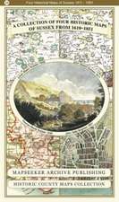
A County of Sussex 1611 - 1836 - Fold Up Map that features a collection of Four Historic Maps, John Speed's County Map 1611, Johan Blaeu's County Map of 1648, Thomas Moules County Map of 1836 and a Plan of the City of Brighton from 1851 by John Tallis. The maps feature a number of vignette views from the period including Brighton's Chain Pier.
2019
Paperback
Preț: 143.23 lei
3-5 săpt. | 6-12 zile