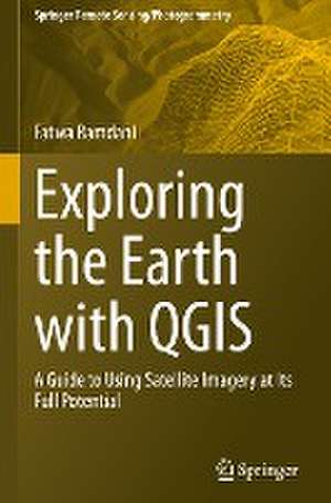
Exploring the Earth with QGIS: Springer Remote Sensing/Photogrammetry
Autor Fatwa Ramdanien Limba Engleză Hardback – 22 noi 2023
There are several books that cover the use of QGIS for earth remote sensing, but most of them areeither too technical or too general. This book fills this gap by providing a comprehensive and user-friendly guide to using QGIS for earth remote sensing applications. It includes a range of real-world case studies that demonstrate the power and versatility of QGIS for solving complex problems in earth remote sensing. This will provide readers with practical examples of how to use QGIS for earth remote sensing and inspire them to explore new applications and possibilities. The book is intended for GIS professionals, students (undergraduate and graduate), and researchers who are interested in using QGIS for earth remote sensing applications. It will be particularly useful for those who are new to QGIS or who want to expand their knowledge of the software for remote sensing purposes.
Din seria Springer Remote Sensing/Photogrammetry
- 18%
 Preț: 1065.81 lei
- 24%
 Preț: 1010.19 lei
- 24%
 Preț: 970.86 lei
- 24%
 Preț: 862.78 lei
- 18%
 Preț: 1174.51 lei
- 15%
 Preț: 666.74 lei
- 18%
 Preț: 813.09 lei
- 18%
 Preț: 984.66 lei
- 18%
 Preț: 927.75 lei
- 18%
 Preț: 1152.85 lei
- 18%
 Preț: 730.56 lei
- 18%
 Preț: 980.83 lei
- 18%
 Preț: 1291.39 lei
- 18%
 Preț: 1154.31 lei
- 24%
 Preț: 825.37 lei
- 18%
 Preț: 1148.61 lei
- 20%
 Preț: 614.43 lei
- 18%
 Preț: 1047.06 lei
- 18%
 Preț: 948.87 lei
- 18%
 Preț: 858.07 lei
- 18%
 Preț: 861.03 lei
- 18%
 Preț: 1041.97 lei
- 24%
 Preț: 909.79 lei
- 24%
 Preț: 970.60 lei
Preț: 957.19 lei
Preț vechi: 1259.46 lei
-24%
Puncte Express: 1436
Carte tipărită la comandă
Livrare economică 23-29 decembrie
Livrare prin curier în România Termenul estimat este afișat lângă disponibilitate.
Transport gratuit pentru acest produs Plată online sau ramburs, în funcție de opțiunile comenzii.
Retur gratuit în 14 zile Comandă securizată și suport în română.
Specificații
ISBN-13: 9783031460418
ISBN-10: 3031460413
Pagini: 252
Ilustrații: XIX, 232 p. 300 illus., 283 illus. in color.
Dimensiuni: 160 x 241 x 19 mm
Greutate: 0.54 kg
Ediția:1st edition 2023
Editura: Springer
Colecția Springer Remote Sensing/Photogrammetry
Seria Springer Remote Sensing/Photogrammetry
Locul publicării:Cham, Switzerland
Cuprins
Chapter 1: Introduction to QGIS.- Chapter 2: Plugins.- Chapter 3: Data Acquisition.- Chapter 4: Data Preprocessing.- Chapter 5: Data Management.- Chapter 6: Data Visualization.- Chapter 7: Data Analysis.- Chapter 8: Integration of Remote Sensing Data with Other Spatial Datasets.- Chapter 9: Integration of QGIS with Google Earth Engine (GEE).- Chapter 10: Case Studies and Examples of Earth Remote Sensing Applications Using QGIS.
Notă biografică
Dr. Fatwa Ramdani is currently a Professor at the University of Tsukuba, Japan, within the Graduate School of Humanities and Social Sciences. A graduate of Tohoku University, Japan, his research expertise lies in Geoinformatics, combining geography with information science and technology to analyze spatial phenomena and geospatial datasets. His work provides unique insights into changes in the human-physical environment, addressing fundamental challenges in physical, environmental, and social sciences. Before joining the University of Tsukuba, Dr. Ramdani was a lecturer in the Information Systems Department at Brawijaya University, Indonesia, where he also served as the Director of the Geoinformatics Research Group. Dr. Ramdani has authored several books, including "Exploring the Earth with QGIS: A Guide to Using Satellite Imagery at Its Full Potential," published by SpringerNature. He has also published numerous peer-reviewed articles in conferences and journals, contributing significantly to the field of environmental impact assessment and geospatial data analysis. He is affiliated with esteemed organizations such as the IEEE Geoscience and Remote Sensing Society (IGARSS), the Japan Society of Photogrammetry and Remote Sensing (JSPRS), the Remote Sensing Society of Japan (RSSJ), Japan Geographic Information System Association (GISA) and the European Geosciences Union (EGU). Dr. Ramdani actively serves as an editor and reviewer for various journals, including "Nature", "Climatic Change", "Remote Sensing," "Applied Sciences," "AgriEngineering", and "Network: Computation in Neural Systems." In addition to his research, Dr. Ramdani teaches courses such as "Data Science for Social Sciences" and "Introduction to Geographic Information Systems" at the University of Tsukuba. His dedication to advancing geospatial science and technology continues to contribute to understanding and addressing environmental and societal challenges.
Textul de pe ultima copertă
With the rapid advancements in satellite technology, earth remote sensing has become an indispensable tool for a wide range of applications, from environmental monitoring to disaster management. However, the vast amount of data generated by these satellites can be overwhelming for many researchers and practitioners who lack the necessary skills and tools to process and analyze it. This is where QGIS comes in. QGIS is a powerful, open-source Geographic Information System (GIS) software that has been extensively used in the field of earth remote sensing. It provides a user-friendly platform for processing, analyzing, and visualizing satellite imagery, enabling users to unlock the full potential of earth remote sensing data. The purpose of this book is to help researchers and practitioners who lack the necessary skills and tools to process and analyze satellite imagery using QGIS.
There are several books that cover the use of QGIS for earth remote sensing, but most of them areeither too technical or too general. This book fills this gap by providing a comprehensive and user-friendly guide to using QGIS for earth remote sensing applications. It includes a range of real-world case studies that demonstrate the power and versatility of QGIS for solving complex problems in earth remote sensing. This will provide readers with practical examples of how to use QGIS for earth remote sensing and inspire them to explore new applications and possibilities. The book is intended for GIS professionals, students (undergraduate and graduate), and researchers who are interested in using QGIS for earth remote sensing applications. It will be particularly useful for those who are new to QGIS or who want to expand their knowledge of the software for remote sensing purposes.
There are several books that cover the use of QGIS for earth remote sensing, but most of them areeither too technical or too general. This book fills this gap by providing a comprehensive and user-friendly guide to using QGIS for earth remote sensing applications. It includes a range of real-world case studies that demonstrate the power and versatility of QGIS for solving complex problems in earth remote sensing. This will provide readers with practical examples of how to use QGIS for earth remote sensing and inspire them to explore new applications and possibilities. The book is intended for GIS professionals, students (undergraduate and graduate), and researchers who are interested in using QGIS for earth remote sensing applications. It will be particularly useful for those who are new to QGIS or who want to expand their knowledge of the software for remote sensing purposes.
Caracteristici
Helps researchers and practitioners process and analyze satellite imagery using QGIS Discusses the integration of remote sensing data with other spatial datasets Provides readers with practical examples of how to use QGIS for earth remote sensing
Descriere
Descriere de la o altă ediție sau format:
With the rapid advancements in satellite technology, earth remote sensing has become an indispensable tool for a wide range of applications, from environmental monitoring to disaster management.
With the rapid advancements in satellite technology, earth remote sensing has become an indispensable tool for a wide range of applications, from environmental monitoring to disaster management.