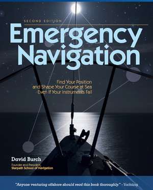
Emergency Navigation, 2nd Edition
Autor David Burchen Limba Engleză Paperback – 16 oct 2008
“Inherently interesting and fun to read . . . provides the clearest understanding of general navigation principles we've seen yet.”--BoatU.S.
“Thorough and authoritative.”--Sea Kayaker
“A definitive work of instant appeal to seamen of all levels of experience.”--The Navigation Foundation
Every sailor knows that instruments can fail. Things get wet, break, fall overboard. Whether you’re safe on your boat or drifting in a life raft, let David Burch show you how to find your way no matter what navigational equipment you have. Often relying on common materials like a small stick, a plastic bottle, even a pair of sunglasses, Burch explains how to make use of all available means--from the ancient skills of Polynesian navigators to the contrails of airliners overhead--to calculate speed, direction, latitude, and longitude and to perform all aspects of piloting and dead reckoning. Learn how to
- Steer by sun, stars, wind, and swells
- Estimate current and leeway
- Improvise your own knotmeter or plumb-bob sextant
- Find the sun in a fogbank
- Estimate latitude with a plate and a knotted string
- And more vital information
Preț: 119.21 lei
Puncte Express: 179
Carte disponibilă
Livrare economică 07-12 august
Livrare express 23-29 iulie pentru 35.04 lei
Livrare prin curier în România Termenul estimat este afișat lângă disponibilitate.
Transport gratuit de la 400.00 lei Plată online sau ramburs, în funcție de opțiunile comenzii.
Retur gratuit în 14 zile Comandă securizată și suport în română.
Specificații
ISBN-13: 9780071481847
ISBN-10: 0071481842
Pagini: 288
Ilustrații: Illustrations, maps
Dimensiuni: 185 x 231 x 20 mm
Greutate: 0.48 kg
Ediția:2nd edition
Editura: McGraw Hill Education
Colecția International Marine/Ragged Mountain Press
Locul publicării:United States
ISBN-10: 0071481842
Pagini: 288
Ilustrații: Illustrations, maps
Dimensiuni: 185 x 231 x 20 mm
Greutate: 0.48 kg
Ediția:2nd edition
Editura: McGraw Hill Education
Colecția International Marine/Ragged Mountain Press
Locul publicării:United States
V-ar putea interesa
-
 ULTIMATE NAVIGATION MANUAL PBLyle BrothertonPreț: 145.85 lei
 -
 Navigation: A Very Short IntroductionJim Bennett-22%Preț: 54.12 lei69.43 lei
 -
 -42%Preț: 64.87 lei112.33 lei
 -
 The Natural Navigator Pocket GuideTristan Gooley-25%Preț: 90.19 lei119.68 lei
 -
 We, the NavigatorsDavid LewisPreț: 203.10 lei
 -
 A Seaman's Guide to Basic ChartworkMalcolm SkenePreț: 111.97 lei
 -
 Yachtmaster for Sail and Power 6th editionRoger Seymour-20%Preț: 191.99 lei239.18 lei
 -
 Reeds Astro Navigation Tables 2024Kendall Carter-42%Preț: 160.67 lei277.20 lei
 -
 Reeds Astro Navigation Tables 2025Kendall Carter-43%Preț: 157.05 lei274.26 lei
 -
 Reeds Marine Distance Tables 19th editionKendall Carter-43%Preț: 187.09 lei327.85 lei
 -
 The Complete Yachtmaster 11th editionTom Cunliffe-18%Preț: 235.38 lei285.92 lei
 -
 Reeds Nautical Almanac 2026Perrin Towler-37%Preț: 335.45 lei533.50 lei
 -
 Reeds Astro Navigation Tables 2026Kendall Carter-44%Preț: 166.38 lei297.79 lei
 -
 Celestial Navigation for Yachtsmen: 13th editionMary Blewitt-43%Preț: 58.63 lei102.93 lei
 -
 -52%Preț: 92.90 lei194.21 lei
 -
 -42%Preț: 195.17 lei333.63 lei
 -
 Preț: 108.31 lei
 -
 Navigation CompanionTim DavisonPreț: 62.26 lei
 -
 Introduction to Celestial NavigationAlexander Arnfinn Olsen-19%Preț: 613.87 lei757.87 lei