CENAS: Water Science and Technology Library, cartea 28
Editat de Giuseppe Gambolatien Limba Engleză Hardback – 31 iul 1998
Din seria Water Science and Technology Library
- 18%
 Preț: 969.78 lei
 - 18%
 Preț: 925.75 lei
 - 18%
 Preț: 904.15 lei
 - 15%
 Preț: 633.77 lei
 - 18%
 Preț: 965.42 lei
 - 18%
 Preț: 863.20 lei
 - 18%
 Preț: 937.81 lei
 - 5%
 Preț: 1185.90 lei
 -
 Preț: 441.90 lei
 - 18%
 Preț: 714.46 lei
 - 15%
 Preț: 627.62 lei
 - 18%
 Preț: 1231.19 lei
 - 18%
 Preț: 1234.12 lei
 - nou
 Preț: 1067.76 lei
 - 18%
 Preț: 960.47 lei
 - 18%
 Preț: 752.50 lei
 - 18%
 Preț: 1182.95 lei
 - 24%
 Preț: 977.65 lei
 - 18%
 Preț: 1129.52 lei
 - 18%
 Preț: 962.26 lei
 - 24%
 Preț: 898.72 lei
 - 18%
 Preț: 958.16 lei
 - 18%
 Preț: 1070.72 lei
 - 18%
 Preț: 1112.60 lei
 - 18%
 Preț: 1124.63 lei
 - 15%
 Preț: 619.75 lei
 - 18%
 Preț: 1121.98 lei
 - 18%
 Preț: 707.96 lei
 - 24%
 Preț: 832.69 lei
 - 18%
 Preț: 898.67 lei
 - 24%
 Preț: 1039.73 lei
 - 18%
 Preț: 1026.83 lei
Preț: 959.94 lei
Preț vechi: 1170.66 lei
-18%
Puncte Express: 1440
Carte tipărită la comandă
Livrare economică 12-26 septembrie
Livrare prin curier în România Termenul estimat este afișat lângă disponibilitate.
Transport gratuit pentru acest produs Plată online sau ramburs, în funcție de opțiunile comenzii.
Retur gratuit în 14 zile Comandă securizată și suport în română.
Specificații
ISBN-13: 9780792351191
ISBN-10: 0792351193
Pagini: 364
Ilustrații: XIII, 346 p.
Dimensiuni: 160 x 241 x 27 mm
Greutate: 0.78 kg
Ediția:1998
Editura: Springer
Colecția Water Science and Technology Library
Seria Water Science and Technology Library
Locul publicării:Dordrecht, Netherlands
ISBN-10: 0792351193
Pagini: 364
Ilustrații: XIII, 346 p.
Dimensiuni: 160 x 241 x 27 mm
Greutate: 0.78 kg
Ediția:1998
Editura: Springer
Colecția Water Science and Technology Library
Seria Water Science and Technology Library
Locul publicării:Dordrecht, Netherlands
V-ar putea interesa
-
 -30%Preț: 422.92 lei605.94 lei
 -
 Natural DisastersD.E. Alexander-18%Preț: 930.30 lei1134.52 lei
 -
 -15%Preț: 597.79 lei703.28 lei
 -
 The Danube: A River Basin in TransitionI.L. Murphy-15%Preț: 621.48 lei731.15 lei
 -
 -18%Preț: 920.88 lei1123.02 lei
 -
 -18%Preț: 912.55 lei1112.87 lei
 -
 Flow Through Heterogeneous Geologic MediaTian-Chyi Yeh-27%Preț: 513.33 lei699.67 lei
 -
 Unsteady Flow in Open ChannelsJurjen A. Battjes-11%Preț: 553.37 lei621.77 lei
 -
 Water Resources and Hydrometeorology of the Arab RegionMamdouh Shahin-24%Preț: 899.02 lei1182.93 lei
 -
 Applied HydrogeophysicsHarry Vereecken-18%Preț: 1750.80 lei2135.13 lei
 -
 Moment Analysis for Subsurface Hydrologic ApplicationsRao S Govindaraju-15%Preț: 641.80 lei755.06 lei
 -
 Monitoring and Modelling Lakes and Coastal EnvironmentsPratap K. Mohanty-15%Preț: 619.91 lei729.31 lei
 -
 Modelling and Monitoring of Coastal Marine ProcessesRaj C. Murthy-15%Preț: 620.07 lei729.49 lei
 -
 Hydrology: A Science for EngineersAndre Musy-18%Preț: 1495.58 lei1823.87 lei
 -
 HydrologyM. Robinson-18%Preț: 739.18 lei901.44 lei
 -
 Nile River BasinAssefa M. Melesse-18%Preț: 1197.49 lei1460.35 lei
 -
 -15%Preț: 619.14 lei728.39 lei
 -
 Aquifer Test SolutionsLeonid N. Sindalovskiy-18%Preț: 763.89 lei931.58 lei
 -
 Fundamentals of Statistical HydrologyMauro Naghettini-18%Preț: 778.80 lei949.76 lei
 -
 -18%Preț: 1351.11 lei1647.71 lei
 -
 Physics of desertificationM. H. A. Hassan-18%Preț: 926.75 lei1130.18 lei
 -
 -18%Preț: 1772.36 lei2161.41 lei
Public țintă
ResearchCuprins
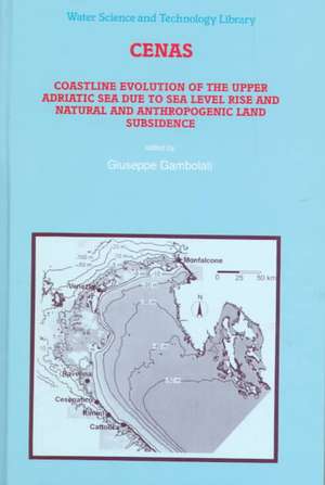
1 Coastal Evolution of the Upper Adriatic Sea due to Sea Level Rise and Natural and Anthropic Land Subsidence.- 1.1 Introduction.- 1.2 Description of the Study Area.- 1.3 Predicted Sea Level Rise due to Global Change.- 1.4 Numerical Simulation of Processes Controlling the Coastal Morpho-dynamics.- 1.5 Local scale morphodynamics along the Romagna coast.- 1.6 Macro- and Local Scale Littoral Dynamics and Risk Analysis.- 1.7 Conclusion.- References.- 2 Prediction of Mean Sea Level Rise in the Upper Adriatic Sea.- 2.1 Introduction.- 2.2 Mean Sea Level Changes.- 2.3 Sea Level Fluctuations.- References.- 3 Collection and analysis of historical data on shoreline evolution at the sites of Ravenna, Cesenatico and Rimini.- 3.1 Introduction.- 3.2 Sea Works.- 3.3 The Evolution of the Beach.- References.- 4 Numerical Modeling of Natural Land Subsidence over Sedimentary Basins Undergoing Large Compaction.- 4.1 Introduction.- 4.2 Governing Equations.- 4.3 Numerical solution: Lagrangian approach.- 4.4 Numerical solution: Eulerian approach.- 4.5 Analysis of the total stress variation during compaction with zero sedimentation rate.- 4.6 Preliminary results from the non-linear compaction-sedimentation model.- 4.7 Conclusions.- References.- 5 Numerical Analysis of Land Subsidence due to Natural Compaction of the Upper Adriatic Sea Basin.- 5.1 Introduction.- 5.2 Geological Setting of the Upper Adriatic Sea Basin.- 5.3 Constitutive Soil Model for the Upper Adriatic Sea Basin.- 5.4 Average Depositional Rates During Middle-Upper Pleistocene and Holocene.- 5.5 Records of Natural Land Subsidence.- 5.6 Numerical Analysis of Upper Adriatic Sea Basin Compaction.- 5.7 Conclusion.- References.- 6 Simulation of Land Subsidence Due to Gas Production at Ravenna Coastline.- 6.1 Introduction.- 6.2 Basic Model Formulation.- 6.3 Implementation of the Nonlinear Reservoir Model.- 6.4 Compressibility vs Effective Intergranular Stress for the Sediments of the Upper Adriatic Sea Basin.- 6.5 Angela Angelina Gas Field.- 6.6 Prediction of Land Subsidence over Angela Angelina Gas Field.- 6.7 Conclusions.- References.- 7 Prediction of Land Subsidence Due to Groundwater Withdrawal along the Emilia-Romagna Coast.- 7.1 Introduction.- 7.2 Subsidence of the Romagna Coastline.- 7.3 Hydrological Model of the Romagna Area.- 7.4 Land Subsidence Model.- 7.5 Conclusions.- References.- 8 Wave refraction in the Upper Adriatic Sea.- 8.1 Introduction.- 8.2 The Adriatic Sea Wave Climate.- 8.3 The Model.- 8.4 Model Results.- 8.5 Conclusions.- References.- 9 Storm Wave Simulation in the Adriatic Sea.- 9.1 Introduction.- 9.2 Storm Wave Information.- 9.3 Selected Storms.- 9.4 The WAM Model.- 9.5 Adriatic Sea Implementation of the WAM Model.- 9.6 Future situation: year 2050 and 2100.- 9.7 Conclusions.- References.- 10 Storm Surge Simulations in the Adriatic Sea.- 10.1 Storm Surges Prediction.- 10.2 Nature of Storm Surges in the Adriatic Sea.- 10.3 Scope of the CENAS Study.- 10.4 Mathematical Formulation.- 10.5 Meteorological Forcing.- 10.6 Open boundary condition.- 10.7 Simulation of Tides in the Adriatic Sea.- 10.8 Simulation of Storm Surges in the Adriatic Sea.- 10.9 Scenarios.- 10.10Conclusions.- References.- 11 Coastal Morphodynamics in Subsiding Areas.- 11.1 Introduction.- 11.2 The Coastal Sediment Balance.- 11.3 Morphological Baseline Study.- 11.4 Coastline Evolution.- 11.5 Summary and Conclusions.- References.- 12 Local Morphological Evolution of the Coast in the Upper Adriatic Sea. Design and Management Strategies to Control Coastal Erosion.- 12.1 Introduction.- 12.2 Local Processes Near Offshore Breakwaters.- 12.3 Coastal Evolution: Observed and Simulated.- 12.4 The Different Role of the Various Factors Contributing to the Shore-line Evolution and to the Risk of Coastal Lowland Flooding.- 12.5 Territory Management Strategies.- 12.6 Coastal Defences for Beach Protection. Objectives and Strategies.- References.- 13 Geographic Information System (GIS) and Data Management and Retrieval System (DMRS) in the CENAS Project.- 13.1 Introduction.- 13.2 The GIS component of the CENAS Project.- 13.3 The DMRS component of the CENAS project.- References.- 14 Flood Risk Analysis in the Upper Adriatic Sea due to Storm Surge, Tide, Waves, and Natural and Anthropic Land Subsidence.- 14.1 Introduction.- 14.2 Macro Scale Littoral Dynamics and Risk Analysis.- 14.3 Local Scale Analysis.- 14.4 Conclusion.- References.- Author Index.- List of Contributors.- Color Plates.