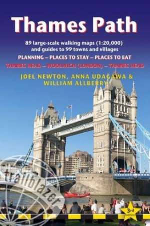
Thames Path Trailblazer Walking Guide 3e: Trailblazer Guides
Autor Joel Newtonen Limba Engleză Paperback – 30 mai 2022
The path begins, as the river does, in a meadow in the Cotswolds; its upper reaches lonely and wild, the meadows and banks the domain of waterfowl and willows; a collage of wild flowers, otters, fishermen and farmers. As the waters deepen and spread the settlements along its banks gradually begin to grow in both size and grandeur, and reaching Oxford, the solitude of the river slowly subsides and the trail becomes as much about historic towns, churches, abbeys and castles as it does the river. Lechlade, Abingdon, Wallingford, Henley ... they all owe their location to the Thames, and different eras, when the river was a life source, a place of conflict, a boundary, a mode of transport and the provider of leisure, which, thankfully—for us, at least—it remains to this day. Squeezing through the ancient Goring Gap, loomed over by the Chiltern Hills, you pass Runnymede—the site of the signing of Magna Carta—and Windsor Castle; where the aeroplanes overhead hint at the ominous size of the city to come.
Walking in London is not as blighted by sound, fury and concrete as many may imagine, as the river—and especially the route along the south bank in London—remains relatively countrified, at least as far as Putney, from which the approaching sights of Westminster and Tower Bridge offer comparably fine vistas to anywhere along the Thames' green and scenic upper reaches. Leaving central London, the regenerated dockland areas of East London (ideas of what constitutes 'wild' in the modern world are of course open to debate) lure you to your journey's end and the conclusion of a most enjoyable and magnificently-varied riparian ramble, quite like no other in Britain.
Yet the Thames Path is more than just a trek, more than a long walk, more than just a national trail; the river acts as a postgraduate course in the history of a nation, a counselor to the modern world, a reminder of the importance of protecting the natural habitats which gave us what we have....
But most importantly—at least, for those wishing to spend some time in the river's company, and indeed planning on doing so with the help of this book—the Thames Path is a fluvial escapade of the finest kind.
- Includes 90 walking maps—the largest-scale maps available. At a scale of just under 1:20,000 (8cm or 3-1/8 inches to one mile) these are bigger than the most detailed walking maps currently available in the shops.
- Unique mapping features—walking times, directions, tricky junctions, places to stay and eat, points of interest. These are not general-purpose maps but fully-edited maps drawn by walkers for walkers.
- Itineraries for all walkers—whether hiking the 184-mile route in its entirety or sampling the highlights on day walks or short breaks.
- Includes detailed public transport information for all access points.
- Practical information for all budgets—what to see, where to stay, where to eat: pubs, hotels, B&B, camping, bunkhouses, hostels.
- GPS waypoints. These are also downloadable from the Trailblazer website.
- Plus—extra color sections: 16pp color introduction and 16pp of color mapping for stage sections (one stage per page) with trail profiles.







Preț: 93.66 lei
Puncte Express: 140
Carte disponibilă
Livrare economică 07-21 noiembrie
Livrare express 24-30 octombrie pentru 22.65 lei
Livrare prin curier în România Termenul estimat este afișat lângă disponibilitate.
Transport gratuit de la 400.00 lei Plată online sau ramburs, în funcție de opțiunile comenzii.
Retur gratuit în 14 zile Comandă securizată și suport în română.
Specificații
ISBN-13: 9781912716272
ISBN-10: 1912716275
Pagini: 278
Ilustrații: 60 colour photos, 4pp colour flower guide, 89 large-scale trail maps printed in two colours and 99 town and village plans, 14 colour stage maps and 2 colour overview maps
Dimensiuni: 118 x 178 x 18 mm
Greutate: 0.27 kg
Ediția:3 New edition
Editura: Trailblazer Publications
Colecția Trailblazer Guides
Seria Trailblazer Guides
ISBN-10: 1912716275
Pagini: 278
Ilustrații: 60 colour photos, 4pp colour flower guide, 89 large-scale trail maps printed in two colours and 99 town and village plans, 14 colour stage maps and 2 colour overview maps
Dimensiuni: 118 x 178 x 18 mm
Greutate: 0.27 kg
Ediția:3 New edition
Editura: Trailblazer Publications
Colecția Trailblazer Guides
Seria Trailblazer Guides
Notă biografică
Joel Newtonis a keen outdoorsman, having completed most of Britain's long-distance paths. He is the co-author of three other British Walking Guides from Trailblazer: Exmoor & North Devon Coast Path, Cornwall Coast Path and Dorset & South Devon Coast Path.
Anna Udagawa is co-author of Trailblazer's Japan by Rail and has worked in travel publishing for many years.
Rev William Allberry is a keen hiker and retired vicar based in London.
Anna Udagawa is co-author of Trailblazer's Japan by Rail and has worked in travel publishing for many years.
Rev William Allberry is a keen hiker and retired vicar based in London.
Descriere
Practical, all-in-one guide to walking the Thames Path National Trail from the Costwolds to the Thames Barrier in London, including large-scale trail maps, places to stay, places to eat and public transport information. Two-way edition.