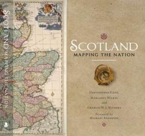
Scotland: Mapping the Nation
Autor Christopher Fleet, Margaret Wilkes, Charles W J Withersen Limba Engleză Hardback – 26 dec 2017
Whilst documents and other written material are obvious resources that help shape our view of the past, maps too can say much about a nation's history. This is the first book to take maps seriously as a form of history, from the earliest representations of Scotland by Ptolemy in the second century AD to the most recent form of Scotland's mapping and geographical representation in GIS, satellite imagery and SATNAV.
Compiled by three experts who have spent their lives working with maps, Scotland: Mapping the Nation offers a fascinating and thought-provoking perspective on Scottish history which is beautifully illustrated with complete facsimiles and details of hundreds of the most significant manuscript and printed maps from the National Library of Scotland and other institutions, including those by Timothy Pont, Joan Blaeu and William Roy, amongst many others.
Preț: 277.13 lei
Puncte Express: 416
Carte disponibilă
Livrare economică 11-25 mai
Livrare express 25 aprilie-01 mai pentru 112.92 lei
Specificații
ISBN-13: 9781780274836
ISBN-10: 1780274831
Pagini: 336
Ilustrații: Maps; Illustrations, color; Maps; Illustrations, color
Dimensiuni: 256 x 258 x 38 mm
Greutate: 2.05 kg
Ediția:2nd edition
Editura: BIRLINN
ISBN-10: 1780274831
Pagini: 336
Ilustrații: Maps; Illustrations, color; Maps; Illustrations, color
Dimensiuni: 256 x 258 x 38 mm
Greutate: 2.05 kg
Ediția:2nd edition
Editura: BIRLINN
V-ar putea interesa
-
 ScotlandMagnus MagnussonPreț: 132.71 lei
 -
 History of Cities in MapsPhilip ParkerPreț: 225.17 lei
 -
 Preț: 267.78 lei
 -
 -14%Preț: 273.97 lei319.16 lei
 -
 To the Ends of the EarthPhilip Parker-21%Preț: 150.53 lei191.66 lei
 -
 A History of Britain in 100 MapsJeremy BlackPreț: 299.82 lei
 -
 -18%Preț: 256.18 lei312.19 lei
 -
 The Library of Lost MapsJames CheshirePreț: 256.97 lei
 -
 Glasgow: Mapping the CityJohn MoorePreț: 233.03 lei
 -
 Scotland: A History from Earliest TimesAlistair MoffatPreț: 120.26 lei
 -
 Scottish PlacenamesDavid RossPreț: 47.25 lei
 -
 Lonely Planet Scotland Planning MapLonely Planet-9%Preț: 39.48 lei43.31 lei
 -
 Scotland's GeomythographyStuart MchardyPreț: 61.70 lei
 -
 Maps: Their Untold Stories 2nd EditionRose Mitchell-27%Preț: 139.16 lei191.04 lei
 -
 On The Map: Why the world looks the way it doesSimon Garfield-19%Preț: 73.17 lei90.28 lei
 -
 Map of a NationRachel HewittPreț: 90.37 lei
 -
 -24%Preț: 54.11 lei71.23 lei
 -
 -23%Preț: 83.41 lei108.18 lei
Descriere
Reissue of this beautifully illustrated hardback gift book with full-colour plates