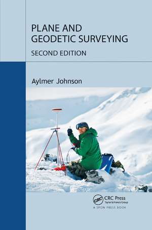
Plane and Geodetic Surveying
Autor Aylmer Johnsonen Limba Engleză Paperback – 10 dec 2019
It fully and clearly explains the concepts and formulae needed to convert instrument readings into useful and reliable results. It offers rigorous explanations of the theoretical background to surveying, while at the same time providing a wealth of useful advice about conducting a survey in practice. The book also contains an accompanying least square adjustment program that is available for free download.
What’s New in the Second Edition:
- Revises and updates the text to reflect recent developments in satellite navigation, laser scanners and total stations
- Provides a more rigorous treatment of how to calculate and use mean earth curvature in geodetic geometry
- Includes substantial additional information on precise levelling, spherical and ellipsoidal geometry, trigonometric heighting and setting out
- Offers a fuller description of mapping systems, including the State Plane Coordinate System
This book is essential for all students of surveying and for practitioners who need a ‘stand-alone’ text for further reading.
Preț: 419.09 lei
Puncte Express: 629
Carte tipărită la comandă
Livrare economică 04-18 iunie
Specificații
ISBN-13: 9780367868246
ISBN-10: 0367868245
Pagini: 276
Dimensiuni: 156 x 234 x 15 mm
Greutate: 0.4 kg
Ediția:2nd edition
Editura: CRC Press
Colecția CRC Press
ISBN-10: 0367868245
Pagini: 276
Dimensiuni: 156 x 234 x 15 mm
Greutate: 0.4 kg
Ediția:2nd edition
Editura: CRC Press
Colecția CRC Press
V-ar putea interesa
-
 Understanding Housing DefectsDuncan Marshall-8%Preț: 582.14 lei632.76 lei
 -
 Inspections and Reports on Dwellings: InspectingPhilip Santo-8%Preț: 609.28 lei662.26 lei
 -
 Building Services Design Methodology: A Practical GuideDavid Bownass-18%Preț: 851.61 lei1038.56 lei
 -
 Safe Intrusive Activities on Land Potentially Impacted by ContaminationBritish Drillin APreț: 345.12 lei
 -
 Excel for SurveyorsPhilip Bowcock-15%Preț: 399.57 lei470.07 lei
 -
 -15%Preț: 403.40 lei474.58 lei
 -
 Contract Practice for SurveyorsSimon Birchall-8%Preț: 456.91 lei496.64 lei
 -
 Pipeline Risk Management Manual: Ideas, Techniques, and ResourcesW. Kent Muhlbauer-26%Preț: 656.96 lei892.12 lei
 -
 Piping Materials GuidePeter Smith-22%Preț: 496.23 lei634.72 lei
 -
 Piping Engineering Leadership for Process Plant ProjectsJames Pennock-23%Preț: 417.45 lei542.14 lei
 -
 Profile of the International Valve IndustryRichard Weaver-27%Preț: 9920.27 lei13589.41 lei
 -
 -18%Preț: 1078.91 lei1315.74 lei
 -
 Shotcrete: Engineering DevelopmentsE.S. Bernard-18%Preț: 971.99 lei1185.36 lei
Cuprins
Introduction. General Principles Of Surveying. Principal Surveying Activities. Angle Measurement. Distance Measurement. Levelling. Satellite Surveying. Geoids, Ellipsoids And Co-Ordinate Transforms. Map Projections. Reduction Of Distance Measurements. Adjustment Of Observations. Trigonometric Heighting. Appendices.
Descriere
This book blends theory and practice, conventional techniques, and satellite-based methods. It gives detailed guidance on how and when the principal surveying instruments (total stations, levels, and navigational satellite receivers) should be used. It fully and clearly explains the concepts and formulae needed to convert instrument readings int