Offa's Dyke Path: National Trail Guides
Autor Tony Gowersen Limba Engleză Paperback – 15 iun 2021
* the route split into convenient sections
* Ordnance Survery mapping for the entire route
* comprehensive, up-to-date information on public transport, accommodation and places of interest
* background information on everything from archaeology to wildlife
* lavishly illustrated with colour photography throughout


Preț: 81.36 lei
Preț vechi: 102.52 lei
-21%
Puncte Express: 122
Preț estimativ în valută:
14.38€ • 17.06$ • 12.45£
14.38€ • 17.06$ • 12.45£
Carte disponibilă
Livrare economică 25 februarie-11 martie
Livrare express 10-14 februarie pentru 43.99 lei
Specificații
ISBN-13: 9781781318089
ISBN-10: 1781318085
Pagini: 168
Ilustrații: colour photos
Dimensiuni: 130 x 206 x 12 mm
Greutate: 0.29 kg
Editura: Quarto Publishing Plc
Seria National Trail Guides
ISBN-10: 1781318085
Pagini: 168
Ilustrații: colour photos
Dimensiuni: 130 x 206 x 12 mm
Greutate: 0.29 kg
Editura: Quarto Publishing Plc
Seria National Trail Guides
Cuprins
How to use this guide
Key maps
Distance checklist
Other trails linking with Offa's Dyke Path
Part One: Introduction
A frontier zone • What is Offa's Dyke? • Landscape and geology • Origins and
management of the Path • Pleasures on the way • Wildlife • Planning your walk •
Waymarking • General information • Offa's Dyke Path Passport
Part Two: Offa's Dyke Path
1 Sedbury Cliffs to Monmouth
2 Monmouth to Pandy
3 Pandy to Hay-on-Wye
4 Hay-on-Wye to Kington
5 Kington to Knighton
6 Knighton to Brompton Crossroads
7 Brompton Crossroads to Buttington Bridge
8 Buttington Bridge to Llanymynech
9 Llanymynech to Chirk Mill
10 Chirk Mill to Llandegla
11 Llandegla to Bodfari
12 Bodfari to Prestatyn
Part Three: Useful Information
Contact details • Transport • Accommodation • Tourist information •
Walking holiday providers • Other useful contacts • Further reading • Ordnance
Survey maps covering Offa's Dyke Path • Glossary of Welsh place names
Notă biografică
Tony Gowers was Natural England's Trail Officer for the North Downs Way. He is also co-author of the National Trail Guide to the Thames Path in the Country. He lives in Kent.
Descriere
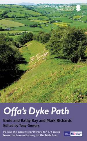
Offa's Dyke Path (Gogledd Llwybr Clawdd Offa) is the 177-mile National Trail following the ancient earthwork that criss-crosses the border country of modern England and Wales, from the Severn Estuary to the seaside resort of Prestatyn on the Irish Sea.