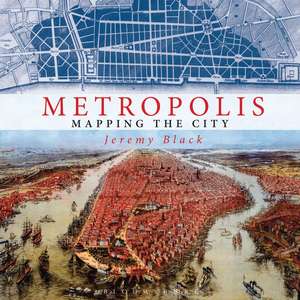
Metropolis: Mapping the City
Autor Jeremy Blacken Limba Engleză Hardback – 7 oct 2015
În cadrul studiilor de geografie istorică și urbanism, volumul Metropolis se poziționează ca o resursă vizuală esențială pentru înțelegerea modului în care omenirea a încercat să cartografieze complexitatea vieții citadine. Remarcăm o structură riguroasă care nu se limitează la simpla prezentare cronologică, ci investighează ideologiile din spatele reprezentărilor grafice, de la primele atlase din secolul al XVI-lea până la viziunile futuriste contemporane.
Observăm că autorul, Jeremy Black, utilizează cele 200 de ilustrații pentru a demonstra cum hărțile au evoluat de la instrumente de explorare la mecanisme de organizare a spațiului social și economic. Această lucrare completează perspectiva oferită de Cities of the World de Peter Whitfield; în timp ce Whitfield se concentrează pe forma arhitecturală și caracterul istoric al orașelor, Jeremy Black pune accent pe funcționalitatea hărții ca document politic și statistic, explicând cum designul influențează percepția asupra ordinii urbane.
În contextul operei sale vaste, Metropolis continuă preocuparea autorului pentru istoria spațială, regăsită și în Mapping Shakespeare. Totuși, dacă în lucrările sale de istorie politică, precum A Brief History of Germany, accentul cade pe narațiunea evenimențială, aici Jeremy Black lasă imaginea să preia rolul principal, oferind analize critice prin legende detaliate care decodifică simbolismul cartografic. Este un volum în format hardback, publicat de Bloomsbury Publishing, care reușește să transforme studiul cartografiei într-o experiență vizuală captivantă, oferind instrumentele necesare pentru a „citi” un oraș dincolo de limitele sale fizice.
Preț: 208.35 lei
Preț vechi: 275.77 lei
-24%
Carte disponibilă
Livrare economică 08-22 august
Specificații
ISBN-10: 1844862208
Pagini: 224
Ilustrații: 200 colour and b&w illustrations and engravings
Dimensiuni: 280 x 280 x 25 mm
Greutate: 1.81 kg
Editura: Bloomsbury Publishing
Colecția Conway
Locul publicării:London, United Kingdom
V-ar putea interesa
-
 A History of the World in Twelve MapsJerry Brotton-19%Preț: 87.76 lei108.14 lei
 -
 Youth Cultures: Texts, Images, and IdentitiesKerry Mallan-31%Preț: 492.44 lei713.63 lei
 -
 Using HistoryJeremy Black-18%Preț: 177.39 lei215.43 lei
 -
 War in the Modern World since 1815Jeremy Black-18%Preț: 1126.68 lei1374.00 lei
 -
 Peebles 1906Barbara MorrisPreț: 33.46 lei
 -
 A Railroad Atlas of the United States in 1946Richard C Carpenter-15%Preț: 500.91 lei589.30 lei
 -
 A Short History of BritainJeremy Black-18%Preț: 182.23 lei223.14 lei
 -
 The Student Bible AtlasTim DowleyPreț: 70.06 lei
 -
 Wildfire Through StaffordshireAdrian BaggettPreț: 101.38 lei
 -
 Liverpool (Vauxhall) 1864KAY PARROTTPreț: 33.46 lei
 -
 Liverpool (Shaw Street) 1848KAY PARROTTPreț: 33.46 lei
 -
 Nottingham (Arnold & Daybrook) 1899Barrie TrinderPreț: 33.46 lei
 -
 Govan 1894Gilbert BellPreț: 33.46 lei
De ce să citești această carte
Recomandăm această carte pasionaților de istorie și urbanism care doresc să înțeleagă cum s-a schimbat percepția asupra metropolei de-a lungul secolelor. Cititorul câștigă o perspectivă critică asupra hărților, învățând să identifice intențiile din spatele designului grafic. Este un instrument de studiu valoros, susținut de expertiza academică a lui Jeremy Black, oferind o sinteză rară între rigoarea istorică și splendoarea vizuală a atlaselor vechi și moderne.
Despre autor
Jeremy Black este profesor de istorie la University of Exeter și Senior Fellow la Foreign Policy Research Institute din Philadelphia. Este unul dintre cei mai prolifici istorici britanici contemporani, specializat în istorie militară, relații internaționale și, în mod special, cartografie istorică. Expertiza sa în evoluția hărților este recunoscută la nivel mondial, fiind autorul a numeroase lucrări care analizează intersecția dintre geografie și putere. Prin lucrări precum Mapping Shakespeare sau studiile sale despre strategia militară, Black a demonstrat o capacitate unică de a sintetiza volume mari de date istorice în narațiuni accesibile, menținând în același timp un standard academic înalt.
Caracteristici
Notă biografică
Descriere scurtă
Recenzii
A cartographic feast. Delicious. If you've ever wondered why cities work, you'll find the answer in this beautiful book.
Of such global variety that even readers who are familiar with the subject will discover many treasures here for the first time ... Black's ambitious text gives us a short global history not only of city mapping but also of the development of cities themselves. All the many aspects of this essay in human geography, from economics and imperialism to mathematics and environmentalism, are touched on in the author's easygoing style. Most impressive are the well-informed captions.
An absorbing collection of maps or paintings from every century that show how humans have struggled to represent their cities.