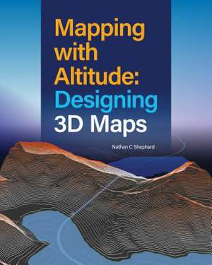
Mapping with Altitude
Autor Nathan C Shepharden Limba Engleză Paperback – 16 iul 2024
Spatial information that is inherently 3D, like buildings, topography, and subsurface geology, can be displayed in a way that is both intuitive and measurable. What's more, 3D representations can be used to model structures before they are built, identifying potential problems.
Mapping with Altitude: Designing 3D Maps helps you deliver clear, compelling cartographic representations in 3D that are both eye-catching and informative. Understand scale, surfaces, base heights, texturing, and lighting models. Discover new twists on well-defined 2D cartographic principles, such as size, color, and text. Consider ways to convey time.
Mapping with Altitude focuses on the decisions you'll make and the specific techniques you can use as you delve into the world of 3D map authoring.
Preț: 482.62 lei
Preț vechi: 567.79 lei
-15%
Carte disponibilă
Livrare economică 05-19 noiembrie
Livrare express 22-28 octombrie pentru 63.77 lei
Specificații
ISBN-10: 158948553X
Pagini: 282
Dimensiuni: 203 x 254 x 18 mm
Greutate: 0.9 kg
Editura: Esri Press
V-ar putea interesa
-
 How to Lie with Maps, Third EditionMark MonmonierPreț: 209.43 lei
 -
 Designer Drafting and Visualizing for the Entertainment WorldPatricia Woodbridge-8%Preț: 521.53 lei566.89 lei
 -
 -13%Preț: 292.30 lei334.57 lei
 -
 Functional Art, TheAlberto CairoPreț: 326.65 lei
 -
 GIS Cartography: A Guide to Effective Map Design, Third EditionGretchen N. PetersonPreț: 374.63 lei
 -
 Perspective Drawing HandbookJoseph D'AmelioPreț: 75.90 lei
 -
 Preț: 134.84 lei
 -
 MapmaticsPaulina Rowinska-48%Preț: 49.02 lei93.56 lei
 -
 How to Make Maps: An Introduction to Theory and Practice of CartographyPeter Anthamatten-5%Preț: 336.39 lei355.93 lei
 -
 Visualize ThisNathan Yau-20%Preț: 233.34 lei291.67 lei
 -
 Data Design: Visualising Quantities, Locations, ConnectionsProfessor Per Mollerup-36%Preț: 200.30 lei312.82 lei
 -
 Preț: 423.22 lei
 -
 -8%Preț: 440.61 lei478.93 lei
 -
 Radical CartographyWilliam Rankin-44%Preț: 133.07 lei237.71 lei
 -
 Semiology of GraphicsJacques Bertin-15%Preț: 606.81 lei713.90 lei
 -
 Designing Better MapsCynthia A Brewer-15%Preț: 480.36 lei565.13 lei
 -
 Telling Stories with MapsAllen CarrollPreț: 270.17 lei
 -
 Tactile MappingVincent van AltenaPreț: 341.45 lei
 -
 Grootens, J: Blind Maps and Blue DotsJoost Grootens-43%Preț: 168.66 lei297.59 lei
 -
 Atlas of Spatial FiguresIgnacio FaríasPreț: 218.64 lei
Notă biografică
Originally from Australia, Nathan C Shephard currently works at Esri headquarters in Redlands, California, where he leads a team of software engineers who work on projects such as 3D and 4D navigation, flood simulation, and the authoring of animation videos. He acts as a 3D evangelist by presenting weird and wonderful 3D maps in technical workshops. In his free time, he writes fiction, shoots arrows, and spends time with his two daughters.
Cuprins
A world of 3D maps
Why 3D?
Anatomy of a 3D scene
Authoring for distance and scale
Delivery formats
Using surfaces
Displaying draped content
Displaying features: Geometry types, base-heights, and anchor points
Displaying features: Form, rotation, and scaling
Displaying features: Textures and materials
Displaying features: Animated symbols
Displaying text and labels
Displaying volumetric content
Temporal content in 3D
Configuring the scene
Exploring the scene
Afterword: Three-dimensional cartography call to action
Index