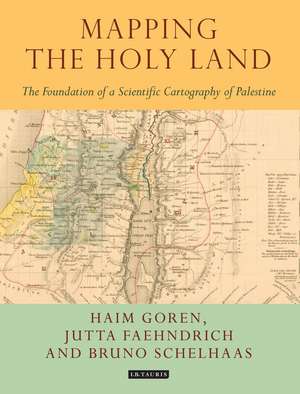
Mapping the Holy Land: The Foundation of a Scientific Cartography of Palestine: Tauris Historical Geographical Series
Autor Bruno Schelhaas, Jutta Faehndrich, Haim Gorenen Limba Engleză Hardback – 9 mai 2017


Preț: 741.71 lei
Preț vechi: 1207.82 lei
-39%
Puncte Express: 1113
Carte disponibilă
Livrare economică 13-27 mai
Specificații
ISBN-13: 9781784534547
ISBN-10: 1784534544
Pagini: 208
Ilustrații: 22 bw maps, 10 colour maps in 16pp plates
Dimensiuni: 190 x 248 x 22 mm
Greutate: 0.82 kg
Editura: Bloomsbury Publishing
Colecția I.B.Tauris
Seria Tauris Historical Geographical Series
Locul publicării:London, United Kingdom
ISBN-10: 1784534544
Pagini: 208
Ilustrații: 22 bw maps, 10 colour maps in 16pp plates
Dimensiuni: 190 x 248 x 22 mm
Greutate: 0.82 kg
Editura: Bloomsbury Publishing
Colecția I.B.Tauris
Seria Tauris Historical Geographical Series
Locul publicării:London, United Kingdom
Cuprins
Preface
List of illustrations
1. Introduction: Mapping the Holy Land
2 Edward Robinson, Eli Smith and the cartography of Berghaus and Kiepert
3. The Land and the Map: C.W.M. van de Velde's Map of the Holy Land
4. August Petermann's Palestine maps
Notes
Archival sources
Bibliography
Index
List of illustrations
1. Introduction: Mapping the Holy Land
2 Edward Robinson, Eli Smith and the cartography of Berghaus and Kiepert
3. The Land and the Map: C.W.M. van de Velde's Map of the Holy Land
4. August Petermann's Palestine maps
Notes
Archival sources
Bibliography
Index