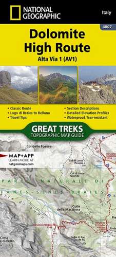
Dolomite High Route: NGS Great Treks Hiking Maps
en Limba Engleză Sheet map – 15 aug 2025
The Alta Via n. 1 (High Route One) of the Dolomites is considered to be the most beautiful classic route in the entire Dolomite territory.
- It connects Lake Braies with Belluno, winds along a route of approximately 125 kilometers (78 miles), with 7,300 meters (23,950 feet) of altitude difference in 12 stages.
- The route cuts from north to south and is normally followed starting from Braies.
- The Alta Via n.
- 1 crosses five different mountain groups: the Braies Dolomites, the Fanes Group (Fanis), the Ampezzo Dolomites, the Northern Dolomites of Zoldo, and the Southern Dolomites of Zoldo.
Every Great Treks map is printed on "Backcountry Tough" waterproof, tear-resistant paper. A full Lat/Long grid is printed on the map to aid with GPS navigation. Every map purchase helps support the National Geographic Society, an impact driven, nonprofit organization with global reach that uses the power of science, exploration, education, and storytelling to illuminate and protect the wonder of our world.
- Folded Size = 4.25" x 9.38"

Preț: 71.77 lei
Puncte Express: 108
Disponibil
Livrare economică 12-26 noiembrie
Livrare express 28 octombrie-03 noiembrie pentru 40.85 lei
Livrare prin curier în România Termenul estimat este afișat lângă disponibilitate.
Transport gratuit de la 400.00 lei Plată online sau ramburs, în funcție de opțiunile comenzii.
Retur gratuit în 14 zile Comandă securizată și suport în română.
Specificații
ISBN-13: 9781566959254
ISBN-10: 156695925X
Pagini: 48
Dimensiuni: 102 x 233 x 5 mm
Greutate: 0.09 kg
Ediția:Neuauflage
Editura: National Geografisch Inst
Seria NGS Great Treks Hiking Maps
ISBN-10: 156695925X
Pagini: 48
Dimensiuni: 102 x 233 x 5 mm
Greutate: 0.09 kg
Ediția:Neuauflage
Editura: National Geografisch Inst
Seria NGS Great Treks Hiking Maps